Претрага
228 items
-
Geotechnical zoning of the terrain along the first section of E-80 highway in Serbia – SEETO route 7
Part of E-80 highway that passes through Serbia (from the city of Nis to the administrative border Merdare) is 77 km long. The highway is divided into two sections: the first from Nis to Plocnik (39.4 km long) and the second from Plocnik to the administrative border with Kosovo. The route is designed through a typical plain and hilly terrain in which different geological units are dominant: crystalline schists, neogene sediments of foothills and quaternary sediments in the valley ...Dragoslav Rakić, Zoran Berisavljević, Irena Basarić, Snežana Bogdanović, Jovana Janković. "Geotechnical zoning of the terrain along the first section of E-80 highway in Serbia – SEETO route 7" in Proceedings of the XVII European Conference of Soil Mechanics and Geotechnical Engineering ECSMGE-2019, Reykjavik, Iceland, 1-6. 09. 2019., ISSMGE, ECSMGE-2019 (2019). https://doi.org/10.32075/17ECSMGE-2019-0393 М33
-
The Flow Conditions in the Epikarst Zone of a Karst Aquifer. Case Study: Suva planina Mt., East Serbia
Branislav Petrović (2022)The epikarst as a part of the karst aquifer represents a complex point of contact and mixing of unconsolidated material from the terrain surface, carbonate rocks altered by “corrosive” water, flora and fauna (and remains of), which is partially saturated with groundwater. Recharge of karst aquifers, usually, occurs via the unsaturated zone which uppermost part could be epikarst zone. Significant amounts of (plant accessible) water, and other solutes and particles, can be stored in this zone for extended periods ...Branislav Petrović. "The Flow Conditions in the Epikarst Zone of a Karst Aquifer. Case Study: Suva planina Mt., East Serbia" in International Scientific Conference - Man and Karst 2022, Custonaci, Italy, 12-16.09.2022, Gruppo Grotte Ragusa - C.I.R.S. (2022) М34
-

Filling of dolines with aeolian sediments in the high-mountain karst of the Dinarides (Mt. Durmitor, Montenegro)
Filling of dolines with aeolian sediments, one of the less frequently described ways in which they are filled, is analysed in the present study on an example of a doline in the high-mountain karst of the Dinarides. There is a series of deep dolines on a broad ridge (about 2450 m a.s.l.) on Mt. Durmitor (Montenegro) in the southeastern part of the Dinarides. The accumulation of very fine-grained sand that almost completely fills one of the dolines was analysed. ...Mirela Djurović, Violeta Gajić, Predrag Djurović. "Filling of dolines with aeolian sediments in the high-mountain karst of the Dinarides (Mt. Durmitor, Montenegro)" in Journal of mountain science, Science Press (2022). https://doi.org/10.1007/s11629-021-7274-5 М23
-
Assessment of spa mineral water quality from Vrnjačka Banja, Serbia: geochemical, bacteriological, and health risk aspects
Nebojša Đ. Pantelić, Simona Jaćimović, Jana Štrbački, Danijela B. Milovanović, Biljana P. Dojčinović, Aleksandar Ž. Kostić (2019)The goal of this study is to evaluate the quality of seven natural mineral water sources in the Vrnjačka Banja area used in the treatment of various diseases. The 24 macro- and microelements were determined by inductively coupled plasma optical emission spectrometry (ICP-OES). The results show that element content was within allowed limits of concentration, except for B, As, and Se. The evaluated content of these elements can be associated with geological and anthropogenic factors. The sample S6 contains ...Nebojša Đ. Pantelić, Simona Jaćimović, Jana Štrbački, Danijela B. Milovanović, Biljana P. Dojčinović, Aleksandar Ž. Kostić. "Assessment of spa mineral water quality from Vrnjačka Banja, Serbia: geochemical, bacteriological, and health risk aspects" in Environmental Monitoring and Assessment, Springer Science and Business Media LLC (2019). https://doi.org/10.1007/s10661-019-7848-7 М22
-
Debris-flow Susceptibility Assessment in Flow-R: Ribnica River Case Study
Debris flows are among the most dangerous erosional geohazards due to the fast rate of movement and long runout zones. Even though the initiation can be triggered in mountainous areas, inhabited and with steep slopes, their propagation and deposition can endanger not only buildings and infrastructure in the urbanized areas, but also threaten human lives. As these initiation areas usually represent unattainable terrains with rapid vegetation cover development, field observations and aerial photo analysis become high-demanding tasks. Consequently, medium-to-regional ...Ksenija Micić, Miloš Marjanović, Biljana Abolmasov . "Debris-flow Susceptibility Assessment in Flow-R: Ribnica River Case Study" in Proceeding of the 6th Regional Symposium on Landslides in the Adriatic-Balkan Region, ReSyLAB 2024, University of Belgrade, Faculty of Mining and Geology (2024). https://doi.org/https://doi.org/10.18485/resylab.2024.6 М33
-
Primena klasterizacije metodom K-srednjih vrednosti za ispitivanje hidrohemijskog diverziteta podzemnih voda na lokaciji Vrnjačke Banje
Klasterizacija metodom k-srednjih vrednosti koristi se za razvrstavanje podataka u homogene grupe, tj. klastere, na osnovu odabranih varijabli i unapred zadatog broja klastera. Algoritam iterativnim postupkom određuje centre klastera i dodeljuje uzorke u klastere čijem su centru najbliži. Ovaj postupak pogodan je za raščlanjivanje i, samim tim, pojednostavljivanje obimnih skupova hidrohemijskih podataka, što je pokazano na primeru termo-mineralnih voda sa šireg područja Vrnjačke Banje. Pored same klasifikacije, opisana metoda pruža mogućnost provere hipoteza o strukturi podataka, npr. o postojanju ...Jana Štrbački, Vladimir Živanović, Nebojša Atanacković, Snežana Kretić. "Primena klasterizacije metodom K-srednjih vrednosti za ispitivanje hidrohemijskog diverziteta podzemnih voda na lokaciji Vrnjačke Banje" in XVII Srpski simpozijum o hidrogeologiji sa međunarodnim učešćem , Pirot, Srbija, 02-06. oktobar 2024, Beograd : Univerzitet u Beogradu - Rudarsko-geološki fakultet (2024). https://doi.org/10.5281/zenodo.13739553 М33
-
A Twitter Corpus and Lexicon for Abusive Speech Detection in Serbian
Uvredljivi govor na društvenim medijima, uključujući psovke, pogrdni govor i govor mržnje, dostigao je nivo pandemije. Sistem koji bi bio u stanju da detektuje takve tekstove mogao bi da pomogne da internet i društveni mediji postanu bolji virtuelni prostor sa više poštovanja. Istraživanja i komercijalna primena u ovoj oblasti do sada su bili fokusirani uglavnom na engleski jezik. Ovaj rad predstavlja rad na izgradnji AbCoSER-a, prvog korpusa uvredljivog govora na srpskom jeziku. Korpus se sastoji od 6.436 ručno označenih ...Danka Jokić, Ranka Stanković, Cvetana Krstev, Branislava Šandrih. "A Twitter Corpus and Lexicon for Abusive Speech Detection in Serbian" in 3rd Conference on Language, Data and Knowledge (LDK 2021), MDPI AG (2021). https://doi.org/10.4230/OASIcs.LDK.2021.13 М33
-
Density maps from gravity inversion as a tool for the basin basement analysis and imaging
Ivana Vasiljević (2023)Previously devised method for density mapping of the Cenozoic basin’s basement is further developed in order to improve the visualization and geological interpretation of the results. The method combines gravity-density inversion with forward modeling and requires gravity anomaly and depth-to-basement data. Although it was primarily designed for application in well-researched basins, such as Pannonian basin, method does not require further constrains. An information on density distribution in the Cenozoic sediments (from density logging or core density measurements) is important ...Ivana Vasiljević. "Density maps from gravity inversion as a tool for the basin basement analysis and imaging" in GEOSCIENCE 2023, Bucharest, Romania, November 9-11, 2023., Bucharest : SGAR - Romanian Society of Applied Geophysics (2023) М32
-
Failure Estimation of the Majdanpek Open Pit East Face Based on Inverse Velocity Model
The Majdanpek open pit mine south district is currently active mining prospect of copper ore exploitation in eastern Serbia. Its depth is approaching the termination depth and occurrences of large-scale instabilities and global instability of the final pit slope is possible. These can generate catastrophic mass movement inside an area that encloses a regional road route and the Pek River bed which is channelled along the outer contour of the pit. The displacements that were noted in early 2023, in the ...Miloš Marjanović, Stefan Milanović, Nikola Simić, Lazar Kričak. "Failure Estimation of the Majdanpek Open Pit East Face Based on Inverse Velocity Model" in Regional Symposium on Landslides in the Adriatic-Balkan Region, Belgrade, 15-18th May 2024, University of Belgrade, Faculty of Mining and Geology (2024). https://doi.org/10.18485/resylab.2024.6.ch46 М33
-
Mineragenetske karakteristike i potencijalnostjuvelirskih mineralnih resursa leckog vulkanskog kompleksa
Zoran Ž. Miladinović (2012-12-11)Jedan od najznačajnijih regiona u Srbiji, sa stanovišta potencijalnosti juvelirskih mneralnih resursa, predstavlja lecki vulkanski kompleks, tercijarne starosti i dominantno andezitskog sastava. Ovaj vulkanski kompleks površine preko 700km2 nalazi se u južnojSrbiji na prostoru imeđu Kuršumlije, Lebana i Medveđe.Prvi su pažnju na juvelirske mineralne sirovine ovog prostora obratili graditeljiJustinijane Prima-e (VI vek). Najintenzivnija istraživanja izvršena su u periodu 1980–1982. ali samo na malom prostoru krajnjeg jugoistočnog dela vulkanskog kompleksa.U Leckom vulkanskom kompleksu dominiraju andezitske stene i njihovi piroklastiti.Smatra se ...vulkanski kompleks, mineragenetske karakteristike, juvelirski mineralni resursi, nalazišta, potencijalnost, kvarc, ametist, ahat, kalcedon, jaspis, prognozaZoran Ž. Miladinović. "Mineragenetske karakteristike i potencijalnostjuvelirskih mineralnih resursa leckog vulkanskog kompleksa" in Универзитет у Београду, Универзитет у Београду, Рударско-геолошки факултет (2012-12-11)
-
Creation of a Training Dataset for Question-Answering Models in Serbian
Razvoj i primena veštačke inteligencije u jezičkim tehnologijama značajno su napredovali poslednjih godina, posebno u domenu zadatka odgovaranja na pitanja (Question Answering - QA). Dok su postojeći resursi za QA zadatke razvijeni za glavne svetske jezike, srpski jezik je relativno zanemaren u ovoj oblasti. Ovaj rad predstavlja inicijativu za kreiranje obimnog i raznovrsnog skupa podataka za obučavanje modela za odgovaranje na pitanja na srpskom jeziku, koji će doprineti unapređenju jezičkih tehnologija za srpski jezik. Pored brojnih istraživanja o jezičkim modelima ...veštačka inteligencija, obrada prirodnog jezika, jezički resursi, anotirani skupovi, ekstrakcija informacija, odgovaranje na pitanjaRanka Stanković, Jovana Rađenović, Maja Ristić, Dragan Stankov. "Creation of a Training Dataset for Question-Answering Models in Serbian" in South Slavic Languages in the Digital Environment JuDig Book of Abstracts, University of Belgrade - Faculty of Philology, Serbia, November 21-23, 2024, University of Belgrade - Faculty of Philology (2024) М64
-
Развој модела конструкције просторија отварања рудника са подземном експлоатацијом
Dražana M. Tošić (2016-08-26)Приликом израде подземних просторија у стјенској маси долази до нарушавања природне равнотеже напонских стања стијенског масива који су владали прије израде тих просторија, при чему долази до појаве прертасподјеле напона и његове концентрације у појединим правцима и тачкама, односно долази до појаве пластичних деформација које су праћене ломљењем стијенске масе и кретањима материјала према откопаном простору...модел, метод коначних елемената, просторија отварања, напон, дефеормација стијенског масива, алгоритам функционалних зависностиDražana M. Tošić. "Развој модела конструкције просторија отварања рудника са подземном експлоатацијом" in Универзитет у Београду, Универзитет у Београду, Рударско-геолошки факултет (2016-08-26)
-
Просторна анализа епикарста у оквиру карстног система источног дела Суве планине
Епикарст представља највиши део стенске масе који је изложен карстификацији, при чему су главне карактеристике епикарста акумулирање подземне воде и стварање услова за формирање концентрисаних токова у подини ове зоне. У досадашњој пракси истраживања епикарста углавном су коришћене индиректне методе: даљинска детекција, анализа хидрограма карстних врела, хидрохемијске и изотопске анализе, па чак и опити трасирања, док је са друге стране јако мали број истраживача изучавао епикарст директним теренским истраживањима. У раду je приказана иновирана методологија истраживања епикарста, која користи ...Бранислав Петровић, Зоран Стевановић, Вељко Мариновић, Снежана Игњатовић. "Просторна анализа епикарста у оквиру карстног система источног дела Суве планине" in XVI српски симпозијум о хидрогеологији са међународним учешћем, Универзитет у Београду, Рударско-геолошки факултет (2022) М63
-
AR, CR and ARCR modeling for simulations and analyses of karst groundwater quality parameters
Although an invisible component of the hydrologic cycle, groundwater generally takes precedence over other water resources in the area of drinking water supply. Among groundwater resources, karst aquifers tend to be rich in sufficiently-accessible amounts of high-quality water. During most of the year, this water requires only disinfection prior to delivery to the end user. However, in many cases extreme rainfall and/or sudden snow melt results in transient turbidity, increase in bacterial count and temporary contamination (e.g. increase in ...autocorrelation, cross-correlation, autoregressive model, cross-regressive model, autocross regressive model, nitrates, Banja Spring, Serbia.Vesna Ristić-Vakanjac, Marina Ćokorilo-Ilić, Petar Papić, Dušan Polomčić, Radisav Golubović. "AR, CR and ARCR modeling for simulations and analyses of karst groundwater quality parameters" in Geološki anali Balkanskoga poluostrva, National Library of Serbia (2018). https://doi.org/10.2298/GABP1879071R М24
-

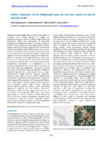
Regional rockfall exposure assessment, experience from Serbia
Rockfalls are common in hilly and mountainous areas, especially along roads with engineered slopes and cuts. Such is the case for most of the state and local road routes in Central, Serbia, which was the subject in this case study. A road network of 276 km covering roughly 1700 km2 between the cities of Kraljevo, Čačak and Ivanjica is presented. Assessing of such wide areas needs to be conducted from large to site-specific scale, i.e., using GIS spatial tools ...Miloš Marjanović, Biljana Abolmasov, Uroš Đurić, Jelka Krušić, Snežana Bogdanović. "Regional rockfall exposure assessment, experience from Serbia" in 5th Regional symposium on landslides in Adriatic–Balkan Region, 23-26 March 2022, Faculty of Civil Engineering, University of Rijeka and Faculty of Mining, Geology and Petroleum Engineering, University of Zagreb (2022) М33
-
Regionalno-geološke karakteristike miocenskih sedimenata na prostoru severnog Banata
Dejan N. Radivojević (2014-12-30)Predmet doktorske disertacije predstavljalo je rešavanje strukturno‐stratigrafskihodnosa miocenskih sedimenata na prostoru severnog Banata. U cilju regionalnogsagledavanja, korišćeni su svi raspoloživi geofizički i geološki podaci sa širegistražnog područja, odnosno iz celog Panonskog basena i susednog orogena. Osimklasičnih metoda primenjene su i savremene metode seizmostratigrafije,tektonostratigrafije i riftne sekvencione stratigrafije. Primenjene metode omogućilesu izradu modela progradacije ivice šelfa za ceo Panonski basen, modela uzajamnihveza između basena i geodinamičkog modela jugoistočnog oboda basena.Jezero Panon je većim delom zapunjeno prilivom sedimenata paleo‐Dunavom saseverozapada, odnosno ...Centralni Paratetis, Panonski basen, miocen, jezero Panon,seizmostratigrafija, sekvenciona stratigrafija, paleogeografija, geodinamikaDejan N. Radivojević. "Regionalno-geološke karakteristike miocenskih sedimenata na prostoru severnog Banata" in Универзитет у Београду, Универзитет у Београду, Рударско-геолошки факултет (2014-12-30)
-
Utilizing sewage wastewater heat in district heating systems in Serbia: effects on sustainability
Marija Živković, Dejan Ivezić (2021)Transformation of the heating sector is recognized as being essential for ensuring reliable and afordable energy services provided with reduced consumption of energy sources and diminished impact on the environment and less import dependency. The possibility of utilizing energy sources that otherwise would be wasted needs to be considered and treated as a big advantage of district heating systems. Despite many advantages, sewage wastewater heat is still a mostly unused resource at the global level and a totally unused ...рекуперација топлоте из отпадних вода, систем даљинског грејања, топлотне пумпе, енергетске уштеде, емисија угљендиоксида, енергетска безбедност, СрбијаMarija Živković, Dejan Ivezić. "Utilizing sewage wastewater heat in district heating systems in Serbia: effects on sustainability" in Clean Technologies and Environmental Policy, Springer Science and Business Media LLC (2021). https://doi.org/10.1007/s10098-021-02063-6 М22
-
Overview of the hydrogeological investigations of recently discovered world class deposits in Serbia
Europe industry has growing concerns on availability of the raw materials. To address this challenge, the European Commission has created a list of critical raw materials for the EU, launched EIT Raw Materials initiative, and continuously support research projects (like INTRAW, UNEXMIN etc.) with the aim of reducing the dependency and meeting growing demands. In the last 15 years Serbia is experiencing new bust in geological exploration of mineral deposits. Currently 167 exploration licenses are active, covering approximately 6000 ...Nebojša Atanacković, Vladimir Živanović, Veselin Dragišić, Sava Magazinović. "Overview of the hydrogeological investigations of recently discovered world class deposits in Serbia" in Proceedings of IAH2019, the 46th Annual Congress of the International Associaton of Hydrogeologists, Málaga (Spain), September 22-27, 2019, International Association of Hydrogeologists (IAH) (2019) М34
-
100th Anniversary of the Carpathian-Balkan Geological Association (CBGA)
Ljupko Rundić (2022)Током 22. конгреса Карпатско-балканске геолошке асоцијације (KБГА) одржаног у Пловдиву, Бугарска (7–11. Септембар, 2022) обележена je стогодишњица оснивања KБГА. Резолуција о оснивању „Карпатске геолошке асоцијације“ усвојена је на 13. Међународног геолошком конгресу у Бриселу, 19. августа 1922.године. То је био резултат ранијих напора и иницијативе Р. Кетнера (Чехословачка), Ј. Новака (Пољска), Г. Мунтеану Мургочија (Румунија) и В. Петковића (Југославија). Касније, после Другог светског рата, асоцијација мења назив у „Карпатско-балканска геолошка асоцијација (КБГА) “. Током протеклих 100 година, КБГА је ...Ljupko Rundić. "100th Anniversary of the Carpathian-Balkan Geological Association (CBGA)" in Геолошки анали Балканскога полуострва, Београд : Рударско-геолошки факултет (2022). https://doi.org/10.2298/GABP221103006R М24
-
Ground surface subsidence monitoring using sentinel-1 in the “Kostolac” open pit coal mine
Zoran Gojković, Milan Kilibarda, Ljiljana Brajović, Miloš Marjanović, Aleksandar Milutinović, Aleksandar Ganić (2023)Open pit coal mining affects surrounding populated areas, resulting in terrain surface deformation. Surface deformation should be monitored as often as possible to control deformations and prevent potential incidents. This paper analyzes time series deformation estimated from the Sentinel-1 satellite images using the Persistent Scatterer Interferometry method to monitor subsidence rates caused by open pit mining activities. It is possible to measure deformations using classical geodetic methods, but those are rarely used in practice because they are time-consuming and ...Zoran Gojković, Milan Kilibarda, Ljiljana Brajović, Miloš Marjanović, Aleksandar Milutinović, Aleksandar Ganić. "Ground surface subsidence monitoring using sentinel-1 in the “Kostolac” open pit coal mine" in Remote Sensing (2023). https://doi.org/10.3390/rs15102519 М21